 Getty Images
Hurricane Erin is expected to intensify, despite being downgraded to a category three storm as it moves towards the Bahamian Archipelago in the Caribbean.
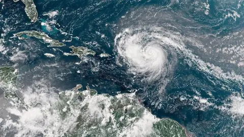
The storm became a rare category five cyclone on Saturday night, with winds up to 160mph (260km/h), but meteorologists expect it to grow in size as it develops over the next few days.
The US National Hurricane Center (NHC) says Erin is forecast to have tropical-storm-strength winds extending 205 miles from its centre. Storm-related hazards, including flash flooding and landslides, are expected in the Virgin Islands and Puerto Rico.
The first hurricane of the 2025 Atlantic season, it is not forecast to make landfall over the mainland US.
Erin underwent rapid intensification as it barrelled towards the Caribbean on Saturday, with NHC director Mike Brennan telling a briefing that it had “explosively deepened and intensified” after growing from tropical storm strength on Friday.
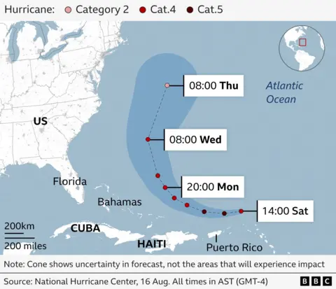
But its windspeeds – along with its forward movement – slowed as it began to turn northwards away from the Caribbean. The NHC expects it to continue to turn away from the US over the course of next week and back into the Atlantic.
The hurricane is currently passing north of Puerto Rico and the Dominican Republic with winds up to 125mph.
Rainfall totals across the Virgin Islands and Turks and Caicos islands are predicted to reach 6in (15cm) on Sunday.
Tropical storm warnings are in place for the Turks and Caicos islands, where strong winds and rip currents – which can rapidly drag people out to sea – are anticipated.
The NHC said Erin was expanding, with hurricane-force winds extending up to 25 miles from its centre as of 09:00 GMT.
The storm will generate life-threatening surf swells and rip currents up almost the entire US east coast, said Mr Brennan.
Florida and mid-Atlantic states will see the most dangerous surf conditions, he said.
Bermuda could also see “life-threatening” surf conditions and heavy rainfall, Mr Brennan added, as well as the Bahamas.
Because of gale force winds, the US Coast Guard is imposing restrictions on vessels at ports on St Thomas and St John in the US Virgin Islands, as well as six municipalities in Puerto Rico, including San Juan.
The National Oceanic and Atmospheric Administration (Noaa), the US government’s primary weather agency, has predicted an “above normal” Atlantic hurricane season this year.
The number of tropical storms that reach category four and five is projected to increase due to global warming.
Predicted path of Hurricane Erin